 login
loginDeer Creek-advice
-
 No new posts


| Moderators: k9car363, alicefoeller | Reply |
|
 2009-08-24 8:36 PM 2009-08-24 8:36 PM |

Veteran  190 190   Delaware, OH Delaware, OH |  Subject: Deer Creek-advice Subject: Deer Creek-adviceJust signed up for Deer Creek! First "big" tri, doing sprint distance. Any words of wisdom from those who have done this race before? |
| 2009-08-24 9:13 PM in reply to: #2368058 |
Champion 7233  | Subject: RE: Deer Creek-advice bike and run course are FLAT!!! only hill on the bike is at the very end, up the side of the dam. run is dead flat, first and last half mile off road (dirt/grass trail), no shade what so ever. swim can be pretty choppy if the wind has picked up. wind is the only real thing to slow you down on this course. |
| 2009-08-25 7:08 AM in reply to: #2368058 |
Veteran 284 | Subject: RE: Deer Creek-advice Deer Creek is a great choice for a first tri. I did my first tri there in '01, and I'd say it's my favorite venue. I'm doing the half IM this year. The bike route is very flat (with a tiny hill toward the end). The run is flat. The swim is flat.  In late September the wind can be dicey. But a breeze on the run feels good. The run from the lake to T1 is a bit on the long side. (IMO) Have you done any open water swimming? If not, try to do some before the race. Practice sighting. I swam like a zig zag my first time. I'd suggest getting there early so you can get through packet pickup and take your time setting up. If your not sure of something ask for help. And don't forget to have fun. Good luck, JC |
| 2009-08-25 7:55 AM in reply to: #2368058 |
Veteran 190 Delaware, OH | Subject: RE: Deer Creek-advice Thanks!! Glad to know the swim is flat...worried about that (lol). Have to get my ducks in a row and be more organized this time. Transitions sucked last time. I will practice as much OWS as I can. My first go-around at OWS was very good-felt very comfortable. |
| 2009-08-25 8:52 AM in reply to: #2368058 |
Expert 716 | Subject: RE: Deer Creek-advice Sweet, a flat swim, I was little worried because I havent been praticing any hills work in the water  |
| 2009-08-25 8:53 AM in reply to: #2368058 |
Master 2014 Ohio | Subject: RE: Deer Creek-advice I rode this course in training back in April. I wrote the summary below and posted it in the Deer Creek thread last spring. Here it is again: I rode this bike course yesterday. I noticed a few things. -It's really windy there. The last time I rode the course (Toyota Tri, last year) and yesterday the wind was pretty bad along Egypt Pike Rd, the first rd you turn on out of the park. Be perpared to get in aero right away and keep the HR high for the first few miles. -Dick Rd is chip-and-seal, narrow and fast. I had a crosswind. I also joined the yellow socks brigade on Dick Rd. (go figure) -Locust Grove is the best spot on the course to make up some time. It's mostly flat and provided me a tail wind. I decided to really push it and see how fast I could go. I hit 30mph. There is one spot along Locust Grove that goes up and crosses another road. Be careful here if you're riding at top speed. -The first major hill of the course is on Crownover. You go down a really nice downhill first. Then, just about the time all the free speed you've gotten is gone, you hit the uphill. If you were able to make up the hills at Miami then this one should not be a problem. It is just as steep but not as long. -The second hill of note is on Egypt Pike. First you go down a long, twisty downhill on Crownover, then you have to slow down and make a left turn onto Egypt Pike and start climbing. I think this is probably the most dangerous turn of the course. In years past they have had police there. Pay attention and be careful. Once you get to the top of this hill the wind hits you in the face again. The nice thing is that if you're doing the sprint you have about a mile of the bike course left. If you're doing the oly you have another lap. |
| 2009-08-26 2:54 PM in reply to: #2368058 |
Master 2210 Columbus, OhioCoaching member | Subject: RE: Deer Creek-advice I would have to say that the 2 hills are not really tiny, depending where you normally train. It's challenging because each hill starts after a turn, so you aren't going top speed when you hit them. I have seen people walking up the one hill. I would drive or ride the course the day before so you will be prepared to shift. That said, I love the course and think it's really fun! The run is SUNNY, though! |
| 2009-08-27 11:23 AM in reply to: #2372386 |
Master 1887 Loveland, Ohio Loveland, Ohio | Subject: RE: Deer Creek-advice ahohl - 2009-08-26 3:54 PM I would have to say that the 2 hills are not really tiny, depending where you normally train. It's challenging because each hill starts after a turn, so you aren't going top speed when you hit them. I have seen people walking up the one hill. I would drive or ride the course the day before so you will be prepared to shift. That said, I love the course and think it's really fun! The run is SUNNY, though! I agree that hill(s) at the end was not tiny and I live and train in a not-so-flat town called "Hillsboro". I had to walk it during my Sprint race last year, though I'm hopeful I won't have to this year. |
| 2009-08-30 9:35 AM in reply to: #2368058 |
Member 22 | Subject: RE: Deer Creek-advice Just as the others have said the bike and run course are pretty open but flat. If it is a windy day the wind could slow you down a bit. Great venue for a first tri. |
| 2009-09-02 7:19 PM in reply to: #2368058 |
| Delaware, OH | Subject: RE: Deer Creek-advice If you can, pick up your race packet on Saturday. |
| 2009-09-02 8:31 PM in reply to: #2368058 |
Veteran 190 Delaware, OH | Subject: RE: Deer Creek-advice Thanks, the cow hill was tough, but I made it up with my big 'ol hybrid!! Hey, another question, I don't have a wetsuit, is that going to be okay for this race? |
| 2009-09-02 8:37 PM in reply to: #2386154 |
| Delaware, OH | Subject: RE: Deer Creek-advice jojoswmr - 2009-09-02 9:31 PM Thanks, the cow hill was tough, but I made it up with my big 'ol hybrid!! Hey, another question, I don't have a wetsuit, is that going to be okay for this race? I don't know! I don't have a wetsuit either....but mother nature gave me a great layer of insulation so I guess I'll just suck it up...or suck it in rather. Oh, I forgot to tell you there is a really big hill you have to run up after the swim. It sucks. But there were tons of people lined up clapping and cheering so I felt guilty and hoofed it up the hill. |
| 2009-09-02 9:03 PM in reply to: #2386164 |
Champion 7233 | Subject: RE: Deer Creek-advice i;m going to be racing without a suit, should not be too bad at all |
| 2009-09-02 9:06 PM in reply to: #2386164 |
Master 1887 Loveland, Ohio | Subject: RE: Deer Creek-advice k_watzek - 2009-09-02 9:37 PM jojoswmr - 2009-09-02 9:31 PM Thanks, the cow hill was tough, but I made it up with my big 'ol hybrid!! Hey, another question, I don't have a wetsuit, is that going to be okay for this race? I don't know! I don't have a wetsuit either....but mother nature gave me a great layer of insulation so I guess I'll just suck it up...or suck it in rather. Oh, I forgot to tell you there is a really big hill you have to run up after the swim. It sucks. But there were tons of people lined up clapping and cheering so I felt guilty and hoofed it up the hill. I'm planning on having a wetsuit by then, just to give me an edge on speed, but I did it last year without one and was completely fine, although it was 2 weeks earlier in the year. I get cold very, very easily if that helps. |
| 2009-09-03 9:34 AM in reply to: #2386219 |
Elite 4504 Columbus, Ohio | Subject: RE: Deer Creek-advice newbz - 2009-09-02 10:03 PM i;m going to be racing without a suit, should not be too bad at all There are laws against streaking in Ohio David. I don't know what you guys do in Colorado but they kinda frown upon it here. I would suggest wearing a suit at the minimum. |
| 2009-09-03 8:57 PM in reply to: #2368058 |
| Delaware, OH | Subject: RE: Deer Creek-advice HA! Except that he is hawt enought that noone would complaine if he ran around nekkid. Edited by k_watzek 2009-09-03 8:57 PM |
| 2009-09-03 9:20 PM in reply to: #2368058 |
Expert 1123 Columbus | Subject: RE: Deer Creek-advice The swim is not flat - it is equal to the curvature of the earths surface sea level. This will be imperceptible to you though because the pull of gravity on you will be equal in all parts of the swim since you and the water surface will not change your relative distance to earth gravitational center. There is that and the fact it is imperceptible to human senses. The following explanation and calculations may help you prepare for the swim: On Earth, the length of an arcdegree of north–south latitude difference, In the case of a spheroid, a meridian and its anti-meridian form an ellipse, from which an exact expression for the length of an arcdegree of latitude difference is: This radius of arc (or "arcradius") is in the plane of a meridian, and is known as the meridional radius of curvature, Similarly, an exact expression for the length of an arcdegree of longitude difference is: The arcradius contained here is in the plane of the prime vertical, the east-west plane perpendicular (or "normal") to both the plane of the meridian and the plane tangent to the surface of the ellipsoid, and is known as the normal radius of curvature, Along the equator (east-west), The WGS84 ellipsoid, used by all GPS devices, uses an equatorial radius of 6378137.0 m and an inverse flattening, (1/f), of 298.257223563, hence its polar radius is 6356752.3142 m and its first eccentricity squared is 0.00669437999014.[4] The more recent but little used IERS 2003 ellipsoid provides equatorial and polar radii of 6378136.6 and 6356751.9 m, respectively, and an inverse flattening of 298.25642.[5] Lengths of degrees on the WGS84 and IERS 2003 ellipsoids are the same when rounded to six significant digits. An appropriate calculator for any latitude is provided by the U.S. government's National Geospatial-Intelligence Agency (NGA).[6]
[edit] Types of latitudeWith a spheroid that is slightly flattened by its rotation, cartographers refer to a variety of auxiliary latitudes to precisely adapt spherical projections according to their purpose. [edit] Common "latitude"In common usage, "latitude" refers to geodetic or geographic latitude The expressions following assume elliptical polar sections and that all sections parallel to the equatorial plane are circular. Geographic latitude (with longitude) then provides a Gauss map. As defined earlier in this article, [edit] Reduced latitude
[edit] Authalic latitude
[edit] Rectifying latitude
[edit] Conformal latitude
[edit] Geocentric latitude
 [edit] Astronomical latitudeA more obscure measure of latitude is the astronomical latitude, which is the angle between the equatorial plane and the normal to the geoid (ie a plumb line). It originated as the angle between horizon and pole star. It differs from the geodetic latitude only slightly, due to the slight deviations of the geoid from the reference ellipsoid. Astronomical latitude is not to be confused with declination, the coordinate astronomers use to describe the locations of stars north/south of the celestial equator (see equatorial coordinates), nor with ecliptic latitude, the coordinate that astronomers use to describe the locations of stars north/south of the ecliptic (see ecliptic coordinates). [edit] PalaeolatitudeContinents move over time, due to continental drift, taking whatever fossils and other features of interest they may have with them. Particularly when discussing fossils, it's often more useful to know where the fossil was when it was laid down, than where it is when it was dug up: this is called the palæolatitude of the fossil. The Palæolatitude can be constrained by palæomagnetic data. If tiny magnetisable grains are present when the rock is being formed, these will align themselves with Earth's magnetic field like compass needles. A magnetometer can deduce the orientation of these grains by subjecting a sample to a magnetic field, and the magnetic declination of the grains can be used to infer the latitude of deposition. [edit] Comparison of selected typesThe following plot shows the differences between the types of latitude. The data used are found in the table following the plot. Please note that the values in the table are in minutes, not degrees, and the plot reflects this as well. Also observe that the conformal symbols are hidden behind the geocentric due to being very close in value. Finally it is important to mention also that these differences don't mean that the use of one specific latitude will necessarily cause more distortions than the other (the real fact is that each latitude type is optimized for achieving a different goal).
[edit] Corrections for altitude When converting from geodetic ("common") latitude to other types of latitude, corrections must be made for altitude for systems which do not measure the angle from the normal of the spheroid. For example, in the figure at right, point H (located on the surface of the spheroid) and point H' (located at some greater elevation) have different geocentric latitudes (angles β and γ respectively), even though they share the same geodetic latitude (angle α). Note that the flatness of the spheroid and elevation of point H' in the image is significantly greater than what is found on the Earth, exaggerating the errors inherent in such calculations if left uncorrected. Note also that the reference ellipsoid used in the geodetic system is itself just an approximation of the true geoid, and therefore introduces its own errors, though the differences are less severe. (See Astronomical latitude, above.) | ||||
 , is about 60
  , is about the same at the equator as the north-south, reducing to zero at the poles.
 .
.
 .
. equals the equatorial radius. The radius of curvature at a
  , is 43 km shorter, hence the length of an arcdegree of latitude difference at the equator is about 1 km less than the length of an arcdegree of longitude difference at the equator. The radii of curvature are equal at the poles where they are about 64 km greater than the north-south equatorial radius of curvature because the polar radius is 21 km less than the equatorial radius. The shorter polar radii indicate that the northern and southern hemispheres are flatter, making their radii of curvature longer. This flattening also 'pinches' the north-south equatorial radius of curvature, making it 43 km less than the equatorial radius. Both radii of curvature are perpendicular to the plane tangent to the surface of the ellipsoid at all latitudes, directed toward a point on the polar axis in the opposite hemisphere (except at the equator where both point toward Earth's center). The east-west radius of curvature reaches the axis, whereas the north-south radius of curvature is shorter at all latitudes except the poles.
 and is the angle between the
  is the
  , form circles whose radii are the same as the radii of circles formed by the corresponding lines of latitude on a sphere with radius equal to the equatorial radius of the spheroid.
 , gives an area-preserving transform to the sphere.
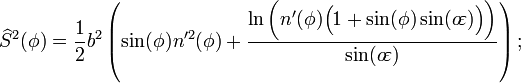

 , is the surface distance from the equator, scaled so the pole is 90°, but involves elliptic integration:
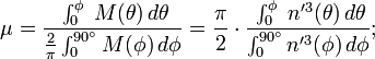
 , gives an angle-preserving (
 , is the angle between the equatorial plane and a line from the center of Earth.


| 2009-09-03 9:31 PM in reply to: #2388667 |
Champion 7233 | Subject: RE: Deer Creek-advice mother of god, brue, its time for a beer man |
| 2009-09-03 9:35 PM in reply to: #2368058 |
Master 2210 Columbus, OhioCoaching member | Subject: RE: Deer Creek-advice Oh crap. I am underprepared for the swim. Where do you store a slide rule in a wetsuit? Also, do these concepts apply to the surface of a beer? |
| 2009-09-03 9:37 PM in reply to: #2368058 |
Master 2014 Ohio | Subject: RE: Deer Creek-advice Funny you should bring that up, Alice. I'm swimming in beer right now. |
| 2009-09-03 9:40 PM in reply to: #2388684 |
Champion 7233 | Subject: RE: Deer Creek-advice that reminds me i have beer in the fridge |
| 2009-09-03 11:17 PM in reply to: #2388687 |
Master 2014 Ohio | Subject: RE: Deer Creek-advice newbz - 2009-09-03 10:40 PM that reminds me i have beer in the fridge Crap, i'm out. Can I come over and "train?" |
| 2009-09-04 6:06 AM in reply to: #2388682 |
Expert 716 | Subject: RE: Deer Creek-advice ahohl - 2009-09-03 10:35 PM Where do you store a slide rule in a wetsuit? Dont get brue started on wetsuits |
| 2009-09-04 7:32 AM in reply to: #2388915 |
Expert 1123 Columbus | Subject: RE: Deer Creek-advice kaiserman19 - 2009-09-04 7:06 AM This is one reason I'll be wearing Mountain Biking shorts. I need pockets. Besides after last weeks Speedo race I am feeling the need for some modesty. I'll probably wear a t-shirt to - you know, like the kids at the city pool do. It will be nice having the t-shirt on in the water because it will help keep me warm as well and I will not nee to spend time in T1 getting it on.ahohl - 2009-09-03 10:35 PM Where do you store a slide rule in a wetsuit? Dont get brue started on wetsuits |
| 2009-09-04 8:08 PM in reply to: #2368058 |
Veteran 190 Delaware, OH | Subject: RE: Deer Creek-advice Oh my god, where has this thread gone to? You ask a simple question and look where it has lead.........Oy Vey! |
|
|
|
|
 View profile
 Add to friends
 Go to training log
 Go to race log
 Send a message
 View album